October 19, 2017
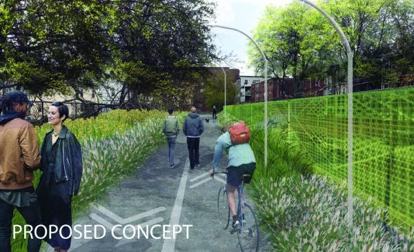
Rendering of the proposed Greenway along the Red Line Tunel Cap envisions a multi-modal path connecting a swath between the Ashmont and Fields Corner T stations. The development team is asking for community input into the path’s best use. Image courtesy RODE Architects.
Partner groups behind a proposed “Dorchester Greenway,” envisioned to transform the Red Line tunnel cap that runs from Park Street just up from Fields Corner to Talbot Avenue at Ashmont, are asking community members via a six-question survey to offer broad-stroke ideas on future uses for the partly fenced-off and largely inhospitable stretch of the cap.
The DotGreenway project, a partnership between Greater Ashmont Main Streets, TLee Development LLC, RODE Architects, and OJB Landscaping, is in the midst of a 10-week comment period that will wrap up at the end of November.
“How can we have it reflect its actual place,” asked Jenn Cartee, executive director of the main street group, “and have it be place-making about Dorchester, not just a trail?”
The project’s CoUrbanize page had listed more than over 450 comments as of Tuesday, with hundreds clamoring for a multi-modal walking and biking path that would serve as a community centerpiece.
“People want everything and a unicorn,” Cartee said. “We’re not going to get a sprinkler park, because there’s enough water issues. But it’s good to hear and get a sense of what are the common requests.”
A mild divide has formed between those who want the path to include gathering spaces and those who hope it will serve more as a picturesque throughway.
“What I will say, which isn’t the final decision of the group, is that the easy and common solution for that is that those linger spots are at outlets, and we have five or six of them,” Cartee said.
She noted that the idea of a Dorchester Greenway in that location aligns with existing city transportation planning. The Boston Bike Network’s 30-year plan, released in 2013, included a the idea of a transit path along the tunnel cap. GoBoston 2030 and the umbrella planning effort ImagineBoston 2030 also include commitments to walk- and bike-friendly main streets, though the tunnel cap is not mentioned specifically.
Every necessary MBTA department has signed off on the plan in principle, Cartee said, in the form of a 99-year lease to the city of Boston for one dollar.
The model the team is looking at, though it is possible it will be revisited, is an easement from the MBTA to the city where the T is responsible for hard-scape maintenance like cracked sidewalks. The city would then license the stretch to a project-specific non-profit, a 501(c)(3) that ideally would form in January. That entity would be responsible for upfront fundraising and programming any soft-scaping along the path.
The Boston Transportation Department would be the direct point of contact, she said. “This is more of a transit route with stuff next to it rather than another park.”
Abutters and surrounding civic associations are being actively engaged, Cartee said. State Representatives Dan Hunt and Dan Cullinane, and City Councillors Ayanna Pressley and Andrea Campbell have offered support for the plan, she said. The group plans to reach out to other elected Dorchester officials.
Following the ongoing feedback period, the partners hope to get more specific input this winter, formulate designs heading into early 2018, and begin fundraising next the summer. If everything goes smoothly, Cartee says, she foresees a 2020 completion date.
To comment on the greenway, fill out the short survey, or stay up to date on the project timeline, visit courbanize.com/projects/dotgreenway.