September 28, 2016
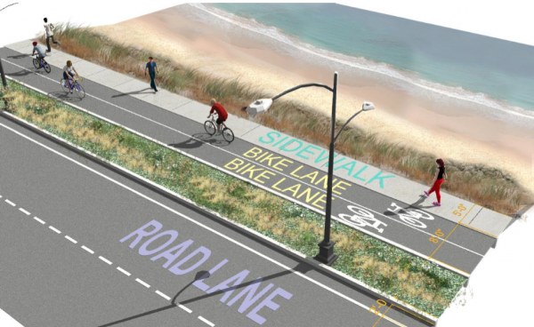
A conceptual design for the 'ocean parkway' segment of Morrissey Boulevard by the boat launch includes separated bicyclist and pedestrian paths. Image courtesy DCR
Conceptual plans for the frequently flooded and gridlocked Morrissey Boulevard were opened for public viewing and input at a state Department of Conservation and Recreation (DCR) meeting Tuesday night in Neponset.
Work on the likely $40 million-project will include a comprehensive overhaul of the 3-mile corridor from Mt. Vernon Street, just below Kosciuszko Circle, to Neponset Circle. The DCR hopes the overhaul will bring the road closer to its intended parkway use.
A public meeting and survey in March highlighted priorities that DCR designers incorporated into plans presented at the evening meeting.
From the feedback gathered so far, Jerry Friedman, municipal and urban design manager with HDR Inc. said designers are trying to reduce traffic speed, as “people think Morrissey Boulevard is seeming too much like highway and much less like a local roadway.” More effectively connecting the neighborhoods to the parks and shoreline is also a priority, he said, with the boulevard currently functioning as “a barrier” to those spaces.
The proposal calls for lowering the posted speed limit from 40 to 35 miles per hour and a lane reduction from three to two in several parts of the road. DCR representatives also laid out broader landscaped sidewalk buffers, additional bicycling and pedestrian paths, and improved crossing locations.
A dramatic narrowing of the road could be in store for the crowded Bianculli Boulevard intersection where one can turn off to access the UMass Boston campus. Where 18 lanes now converge, planners say they could eliminate around a half dozen lanes and speed the traffic flow. Possible modifications include adding a signal to the existing service road, whittling down poorly-designed turn lanes, fine-tuning the signal times, and adding a deceleration lane by the Old Colony Terrace turn.
Pushback at the meeting focused on shared use of the parkway between the various modes of transportation, which DCR project engineer Mark MacLean said was “a balancing act.”
One resident said losing a lane along the stretch would be infeasible. Bill Lambert of Lambert’s Market said, “I see maybe one or two bikes per week,” asking for more consideration for businesses dependent on the roadway, and not at the cost of vital transit lanes.
But cyclists who spoke said more would use the corridor if it was a safer and more pleasant experience. DCR officials emphasized improvements to Morrissey traffic efficiency that would offset the grind of cars clogging some particularly poorly-designed segments.
Morrissey’s redesign doesn’t exist in a vacuum, some noted. Attendees sought answers on the long-term future of the Morrissey corridor, framed on all sides by a number of large land parcels either ripe for development or in the process.
“Is there a plan?” asked Peter Furth. “What are we looking at 30 years from now, 50 years from now as far as commercial development? Is the city encouraging more, and how is that incumbent upon [the work on Morrissey]?”
He was told broader planning is a question for the Boston Redevelopment Authority -- just rebranded as the Boston Planning and Development Agency. When meeting with the planning agency regarding the work alongside the boulevard, “they did not have any specific plans,” Friedman said.
For decades, community members have asked for an overhaul of the roadway, with already dense congestion peaking where Morrissey meets Freeport Street, the crossing to UMass Boston from Bianculli Boulevard, and the top of Mt. Vernon Street.
The stretch of road is often flooded along the DCR-designated middle segment -- from Pattens Cove Bridge to Freeport Street -- making it the most vulnerable and therefore of highest priority.
Completion of each of the three segments is contingent on funding.
DCR representatives said at the meeting that their one-year design process is fully funded for $3.2 million, and they expect to have enough budgeted through the next few state capital plans to at least begin work on phase one.
But preliminary design for the roadway was where the presentation ended on Tuesday. Environmental mitigation, safety metrics, and other subjects will be addressed at a later meeting.
“Nothing is etched in stone,” Friedman said as attendees began to shuffle toward tables covered with roadway mockups, adding that they planned to incorporate additional community feedback into the process.
Public comments on the proposals and the meeting will be open until Oct. 18, which can be submitted online or by writing to the DCR’s office of public outreach. The visual presentation will be available online at DCR’s website, as are materials from the earlier community gathering.