
July 12, 2021
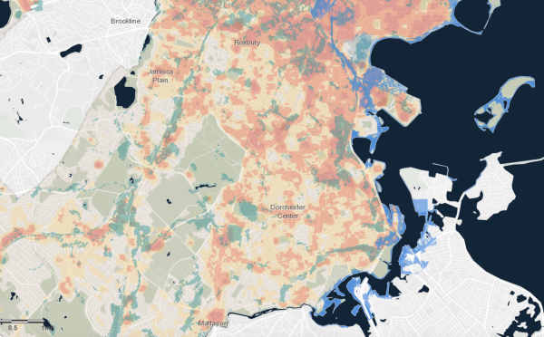
Climate Ready Boston's heat map is an interactive infographic maps heat islands, using daytime land surface temperature to track the city's hottest and coolest regions. (Screenshot)
The city’s Environment Department will hold its second virtual open house on heat resilience on Wednesday as it continues its work to mitigate the impacts of global warming.
The workshop will be an opportunity to highlight existing heat relief measures, including cooling spots at public parks and the Boston Public Library system, as well as emergency relief through Boston 311, and brainstorm new solutions based on community input.
“There’s really a chance not to just cool the city but to do that in an equitable way so that we’re building up our communities today and setting up well the kids that will grow up here tomorrow – that’s a huge part of climate resilience planning,” said Zoë Davis, the department’s Climate Resilience project manager.
Priorities for equitable heat resilience planning include the preservation and planting of trees, water access during heat emergencies, covering street-side bus stops, and repurposing the city’s rooftops as urban farms.
“To move forward with urgency, we should recognize that every day people still experience the effects of climate change, regardless of seasonal movements,” said Davis. “We tend to forget that it gets hot and is only getting hotter, but the effects of climate change are today.”
The process facilitated by Climate Ready Boston, one of three teams leading the environment department’s Healthy Places initiative, will crowdsource community-driven solutions to the unprecedented urban heat plaguing the city’s historically underserved communities.
Researchers overlaid Boston heat maps with 1930’s-era homeowners loan risk maps and found a demonstrable correlation between the city’s hottest spaces and formerly “redlined” neighborhoods. Sections once designated as ‘declining’ or ‘hazardous’ often had more diverse racial makeups than their ‘best’ and ‘desirable’ counterparts, classifications reserved for areas of Jamaica Plain and the western tip of Allston and Brighton.
Decades later, these neighborhoods, present-day Dorchester, Mattapan, Roxbury, Chinatown, and East Boston, are home to the highest concentration of the city’s heat islands.
“The reason why we’re focusing on these neighborhoods is we’re seeing the very real impacts of racist policies and how that also impacts climate change itself,” said Davis.
She added: “We’re recognizing the trends that we’re seeing in extreme heat across the city has been designed. That’s not to say that the intention long ago was to make areas hot, but there’s a reason why we see certain spaces in certain neighborhoods that are hotter than others, and it’s because there’s a history of disinvestment.”
Climate Ready Boston has previously held ‘neighborhood idea sessions’ in each of Boston’s five hottest neighborhoods, discussing contributors to extreme heat in those specific areas and fielding questions from community members in several languages.
The team’s Heat Resilience Open House will take place virtually on Wednesday, July 14 from 6 to 7:30 p.m. It is the second community open house of its kind, and marks the conclusion of the second step of the heat resilience study, stakeholder and public engagement.

Topics: