March 13, 2014
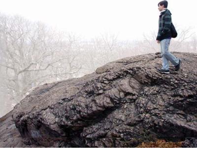
 An outcropping of Roxbury Puddingstone on top of Savin Hill. Photo by James Hobin
Dorchester is approximately six square miles, and almost every square inch of it has been scraped, blasted, planted, slanted, hollowed out, heaped upon, boarded over, wired, piped, poled, and/or paved.
Underfoot, very little remains of our natural environment – very little, that is, except for Roxbury Puddingstone. And if, walking down the street, you happen to come upon an outcropping of Roxbury Puddingstone, you will be looking at something that has been in that spot for millions of years.
The ground on which we stand is built up in layers, like a city set on ancient ruins. The top layer is a thin veneer of sidewalks and roads. Next, there can be up to twelve feet of fill, which is common in urban areas. Beneath that is soil that was deposited about 12,000 years ago, at the end of the last ice age. Beneath that, there is anywhere from 1,500 to 3,000 feet of Roxbury Puddingstone bedrock formed over 300 million years ago. Underneath all of this is another layer of bedrock: igneous granite.
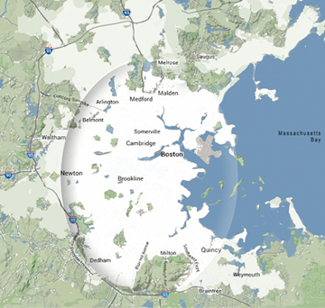
This article refers to events that occurred within an area of a five-to-ten mile radius of present-day Boston. About 400 million years ago, seismic pressure caused fault lines to form along this radius.
The land at the outer edge of the radius was uplifted, while the land inside was lowered. This lowering resulted in the formation of a declivity, or basin, which eventually filled with water to make a bay, ringed by elevations: Middlesex Fells to the north, the Blue Hills to the south, and Arlington Heights to the west. These boundaries are still in place and mark the perimeter of what is known as the Boston Basin.
Far back in geologic time, massive rivers flowed in from all directions, lining the bottom of the Boston Basin with the rocks and silt that were carried downstream. Over millions of years this debris accumulated to a great depth, and, crushed by its own weight, solidified into the sedimentary rock that we now call Roxbury Puddingstone. Of course, it is a lot more complicated than that, but that is the general outline.
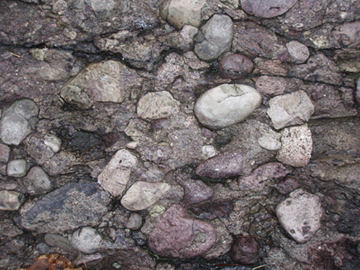
Roxbury Puddingstone is a sedimentary conglomerate, comprising a fine-grained matrix, or silt (the pudding), within which are inclusions of rock, mostly rounded granite. The silt is a mixture of rock flour and the residue of ash left from early volcanic eruptions. The rocks, or “nuts” were rounded by the rivers, which chipped off sharp edges and wore down the rocks as they bumped along in the current. But the most important component of Roxbury Puddingstone is the silt, which hardened and gripped the rocks like stone jello holding together the pieces of a petrified fruit salad.
Where puddingstone is found along the perimeter of the Boston Basin, the rocks will be larger than the rocks located near its center. This is due to the action of the water, which, as energy was expended in transport, dropped the rocks wherever the force of the current was no longer sufficient to propel them forward. In some sections, there were no rocks deposited at all, and clay, silt, and mud, were built up instead. Northern portions of the Boston Basin are underlain by shale, a sedimentary rock composed of layers of compressed clay, silt and mud. Over time, this shale became slate. In Cambridge there is little puddingstone and in Somerville there is less, these areas having a predominant composition of slate.
 Photo by James HobinRoxbury Puddingstone is underground but we can see outcroppings of it throughout Dorchester. Maybe there is a lump of it sitting in a friend’s backyard, or maybe there is a wall of it standing behind a row of triple-deckers, or maybe there is a slab of it leaning over the sidewalk near your house. A lot of times it is hidden by trees and undergrowth. And then there is the plain fact that it has been quarried, dressed, and set into buildings and walls all over town. Roxbury Puddingstone is the rock of Dorchester.
We see outcrops now because back when the puddingstone was forming, enormous lateral pressures exerted by its weight forced huge ridges and arches to rise up. Later, when this area was subjected to the effects of receding glaciers, these puddingstone towers were scraped and battered into hideous shapes. The awesome weight of the glacier bore down and pulverized solid rock into fine-grained till, or rock flour. This rock flour, which became soil, was made up of silt, clay, and fine sand. Torrents of glacial melt water drove this soil into every crevice of the landscape. The soil is packed up to several hundred feet deep in valleys, with less along hillsides, until there is no soil, and bare rock is exposed on hilltops.
Sedimentary conglomerate, of which Roxbury Puddingstone is a variant, is found all over the world, but what makes Roxbury Puddingstone unique is that it contains Dedham Granite and volcanic rock from the ancient underlying Mattapan Volcanic Complex. Deeper analysis of the different components found in rock involves Petrology – the science behind a rock. A specially trained geologist can read a rock as if it were a book. However, for the layman, it is not easy to know why a particular bit of rock looks the way it does or even to be able to tell whether an existing rock formation has been altered in any way by the hand of man – as a road cut, for instance.
A close inspection of a rock wall may reveal a series of vertical indentations. These lines are what remain of holes that were drilled into the rock to blast for road cut. Construction crews packed these holes with dynamite to blow the rock apart and clear it away. Have you ever tried to bust up a chunk of Roxbury Puddingstone? It can display what a rigger calls “refusal.” It can be very stubborn stuff. Yet, sometimes you can see the puddingstone weep, if an underground stream or upland weather event causes moisture to transmit fracture lines, and drain down, leaving the exposed rock face black and shiny and dripping with water.
 A map showing the Boston BasinMany events occurred to make Roxbury Puddingstone, but the story is not over, and time and weathering are still at work. Erosion is an ongoing process, and with as much Roxbury Puddingstone as there is around here now, there once was a lot more. It is hard to image the extent to which our environment has changed over time. But Roxbury Puddingstone is still here, even as it continues to dissolve, bit by bit, into nothingness.
Geology is a complex subject, and only a person with rocks in his or her head would attempt to explain it in a few sentences. This article is a personal essay about preliminary research regarding the historical depositional sequence specific to this locality. It was written from notes on my own “walk around” observations and limited reading, and through discussions on the topic with a professional geologist, architect, and builder.
When it comes to Geology, I do not qualify even as a novice, but I will admit to being an amateur, in the best sense of the word. Amateurs do a thing not because it is their job, but because it brings pleasure to do it. It is the enthusiasms of amateurs that move the world. On the other hand, amateurs are given to spouting generalities that can sometimes verge on misinformation. So, should the reader care for a more technical, in-depth analysis of the geology and landforms of Dorchester, please read on at the links provided below.
To learn more visit roxxbost.wordpress.com. There you will find more information and a listing of the sources that were referenced to write this article. Also, there is a topographical map that shows the general configuration of the Boston Basin; an 1882 map of Roxbury; and links to the US Geological Survey. Special thanks to Joseph Hobin, Compliance Environmental, Inc.
James Hobin’s column appears monthly in the Dorchester Reporter.


