


Tenean Beach would be transformed into a shield against rising sea levels under a plan laid out last Thursday by Boston Planning and Development Agency officials that includes new and expanded basketball and tennis courts, a lawn ideal for small events, shady picnic areas, all joining an existing playground.
The proposal also seeks to connect the new beachscape to an open space network, including the Harborwalk and the Neponset Greenway trail.
Two community workshops have already been held to gather input, and the BPDA has hired SCAPE Landscape Architecture to work up solution possibilities as the area, in particular the beach and nearby Conley Street, which runs under I-93, is expected to face increased flooding in the future.
The agency’s project team worked with DCR and other state and city agencies during the proposal’s design process.
If left untouched, the beach will continue to flood, and eventually affect the MBTA’s Red Line extension to Braintree, which runs through the area, as does the aforementioned I-93. Morrissey Boulevard, another key roadway, is also nearby, and tidewaters and stormwaters regularly flood its lanes close to the entrance into the UMass Boston campus.
The MBTA Red Line sees 240,000 trips per weekday, while 200,000 cars pass by on I-93, according to the report. Morrissey Boulevard accommodates 36,000 cars per day.
“These vital transportation lines move the Dorchester community to their places of work and commerce,” the BPDA report said. “As a result, flooding would cause far-reaching impacts to the City’s economy such as shutdowns due to failure and maintenance, technical, or structural issues. The proposal seeks to minimize this risk in the near-term. In the long-term, it will be necessary to adapt and tie into adjacent ongoing efforts to further reduce risk in this area.”
The report’s focus is on 10 acres that are owned by the Massachusetts Department of Conservation and Recreation (DCR). Beyond the public beach and parking lot, there is a salt marsh. Residences are close by, as are buildings that house Extra Space Storage, electrical and plumbing supply stores, and Boston Bowl. Hundreds of residential units are now going up next to the bowling alley.
Under the proposal, the parking lot would be elevated, with 70 percent of its spaces remaining in place. The Harborwalk would also be elevated, and realigned closer to Conley Street, which itself would be heightened by four feet. A new tree grove would allow for “quiet contemplation and enjoyment of water views,” the report said, and new coastal plantings along Conley Street would provide a buffer to traffic and help with stormwater management.
Maria Lyons, a member of the Port Norfolk Civic Association, said the group “generally” supports the design. But, she added, “we have grave concerns that the blocking of storm water in one direction will cause it to flow in another direction, in this case, into the Port Norfolk residential neighborhood.”
Lawley Street, which is a short skip across the water from the beach, is already experiencing two feet of flooding during storm surges, Lyons said. “We are not convinced by the report that the design for Tenean Beach will not make this worse.”
The BPDA report had an appendix, written by the engineering firm Woods Hole Group, that cited models indicating no flood waters would be redirected into the Port Norfolk neighborhood as a result of Tenean’s overhaul.
According to the report, city officials will seek grant funding for Tenean’s overhaul from a number of potential avenues, including the Federal Emergency Management Agency (FEMA), the National Fish and Wildlife Foundation, and state-level grants. The cost of the project is put at an estimated $12 million.
“Continued discussions are necessary to determine which grants would best serve the project, which grants are most competitive for selection, and what design modifications may be required,” according to the report, which was funded through a $300,000 state grant and a $100,000 matching grant from the city of Boston.
Another study of the area, separate from the Tenean Beach report and focused on the Morrissey Boulevard corridor, is underway, as developers are looking to add thousands of residential units and commercial space. Up the road at Columbia Point, a $5 billion plan called “Dorchester Bay City” is expected to bring new streets and buildings, and serve as a catalyst for improvements to existing roadways and JFK/UMass MBTA Station, a public transit hub.
A commission of state and city officials was tasked with issuing a report on Morrissey Boulevard this past June, but state lawmakers have shifted the due date to June 2024. The eventual recommendations are expected to focus on improving the area for pedestrians, drivers, and public transit users, in addition to strengthening the “climate resiliency” of the area.
This post was updated on Aug. 1 with additional reporting.
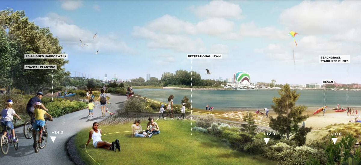
Another rendering of Tenean Beach, with the National Grid gas tank in the background. (Image via BPDA)
