
About 30 people attended meeting held at UMass Boston
Members of the state-run Morrissey Boulevard Commission discussed climate resiliency options for the boulevard’s re-design during its second public meeting on Tuesday evening at UMass Boston. The session was one of four the Commission has planned to discuss reworking Morrissey Boulevard and Kosciuszko Circle to make them safer, more climate resilient and easier to navigate for motorists, pedestrians and cyclists.
In addition, with major developments in the pipeline like Dorchester Bay City, the Commission is tasked with ensuring a new-and-improved Morrissey Boulevard and other infrastructure able to handle the increased traffic. The Legislature ordered the formation of the Commission in 2022 and the first public meeting took place last November.
On Tuesday evening, after some technical difficulties, the Commission – made up of local state legislators and city council representatives, the Mayor’s Office, members of MassDOT, the BPDA, the Executive Office of Energy & Environmental Affairs (EEA) and the UMass Building Authority – listened to a MassDOT presentation that offered three alternatives for resiliency measures: an exposed floodwall, a buried floodwall or levee, or a variation of an enforceable gate that could be controlled during higher or “King” tide events.
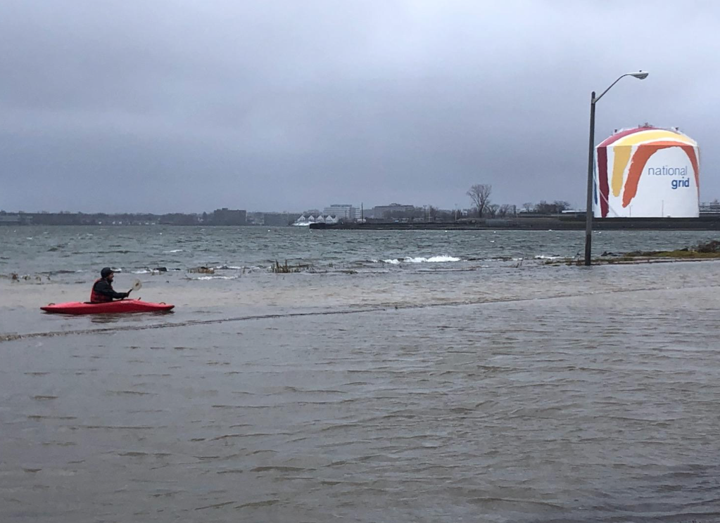
Different types of berms – natural, earthen walls – were also presented as potential options. Several points along the boulevard or nearby were highlighted as being the most at risk for increased tidal flooding: Patten’s Cove, the Dorchester Bay Basin, Tenean Beach, the Neponset River, and Savin Hill Cove.
Some attendees at the meeting— which was scheduled with just one week’s notice to the public— expressed concerns that not enough progress has been made by the project team, led by Ethan Britland at MassDOT. They pointed to a June deadline for seeking funding in the next state budget cycle.
Any plan that emerges from the Commission’s work would need to be recommended by the Legislature to Gov. Healey, who would then make budget recommendations to the Department of Conservation & Recreation or MassDOT to kick the project into gear.
“At this point in the schedule, even if we have to get an extension past June for a project this big, we really need to hear what you are considering,” said John Rich, a Savin Hill resident.
The rotary at Kosciuszko Circle and the Beades drawbridge were two major focal points of concerns raised by members of the public who attended the meeting or watched virtually; namely, the fact that neither was mentioned in MassDOT’s presentation.
At the next meeting — which has not yet been scheduled — David Mohler, director of the office of transportation planning at MassDOT, said they will present updates for the K Circle and Beades Bridge projects, which he said are not under the purview of the Commission, at the request of the residents at Tuesday’s meeting.
Project manager Britland said work is being done behind the scenes to understand how these locations will be impacted, but he said that planning for the two critical infrastructure pieces are ahead of the overall Morrissey Boulevard roadway.
The first Commission meeting in November included remarks from Mayor Wu, who appealed to the newly created panel to coordinate plans for fixes Kosciuszko Circle as part of their work.
Other concerns were voiced about the Savin Hill Yacht Club, which is already regularly inundated by tidal flooding—and how changes to the road system and resiliency measures might impact that property on Morrissey. MassDOT, through Mohler, didn’t have a direct answer, but said that the Yacht Club’s concerns would be taken into consideration in future meetings.
The next Commission meeting— expected to be held sometime in March— will present analyses from MassDOT on which of the climate resilient designs will best suit the respective outlined zones, as well as solicit feedback from the public on what they would like to see.
The commission is the latest attempt to focus state and city resources on the coastal road system that is frequently disrupted by flooding caused by high tides, a problem that is exacerbated by rising sea levels. The state’s Dept. of Conservation and Recreation began a re-design process with a series of public meetings in 2016 and 2017. But the effort stalled, in part, because of controversy involving the idea of dropping a vehicular travel lane in each direction to make way for dedicated bike lanes.
