
October 24, 2018
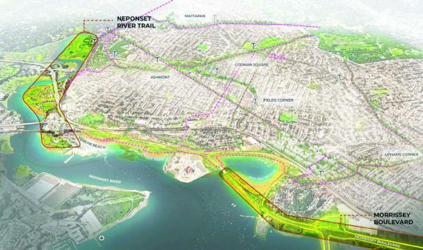
A slide from Mayor Walsh’s presentation before the Greater Boston Chamber of Commerce last week highlighted the potential state projects that the city hopes will help protect Dorchester’s shoreline from impending impacts from climate change. The Neponset Greenway (upper left) and the Morrissey corridor were key planks in the mayor’s plan.
The Walsh administration rolled out an ambitious plan for the climate-vulnerable Boston this month, committing $1 billion to helping the waterfront neighborhoods weather the pressing risk of massive flood scenarios down the line. Now they are turning their eyes to Dorchester, its miles of coastline lined with state-run projects poised to become buffers against the tides.
Climate Ready Dorchester, as the city planning process is called, will move into the consultant stage this fall, according to city officials. As the projects downtown wrap up in Spring 2019, the Dorchester plan should kick off. It is expected to be completed by the end of next year.
Walsh outlined his citywide goals in his annual speech before the Greater Boston Chamber of Commerce last Wednesday.
“The rest of our coastline to the south, we envision as a resilient, accessible, and connected Dorchester shore, the kind you see here,” Walsh said, pointing to a rendering of the coast. “Notice how many residential communities this shoreline can protect.”
Dorchester’s climate plan, as Walsh described it, is largely pinned to massive state-controlled projects like the Morrissey Boulevard redesign, the continuation of the Neponset Greenway across a particularly flooding-susceptible leg of the harbor marsh, and the 20-acre Bayside site, presently owned by UMass.
“At each point in the plan there are challenges,” Walsh said in his speech. “Multiple property owners. Multiple jurisdictions. Funding needs. The Harborwalk alone touches 356 different properties. It’s a shared resource and a shared obligation. We can’t let these manmade hurdles hold us back.”
On juggling these jurisdictional issues, the mayor’s office declined to elaborate beyond the Chamber of Commerce remarks.
State Rep. Dan Hunt, who championed a 2014 state environmental bond bill, noted that from day one he's worked to include funding for environmental projects including elements like sea walls and flood mitigation. The estimated $40 million Morrissey Boulevard project and the multi-million-dollar greenway link have been priorities, Hunt said.
"As far as the overall plan that the mayor’s doing, I think it’s smart and shows a great partnership with the city and the state," he said. With a Dorchester study overlay, it knits together different jurisdictions that ordinarily may focus on driving their own projects.
"I think that previously, studies have been done in vacuums," Hunt said, "and I’m doing what I’m doing on the state level as far as pushing for the bond bill and pushing these through, and mayor is focusing on the intersection of city and state and making sure the city projects and state projects are done in conjunction. Previously, the state would look at their portion of a street or a beach and not look at the other subset, and the city would do the same thing. The city is putting money where its mouth is and spending on a study of all properties, city, state, and private."
Work on re-designing Morrissey Boulevard is moving toward the 75 percent design stage for a substantial redesign that would transform the busy road into a more efficient, accessible, and attractive parkway. One of the engineering goals will be to elevate the roadway along its lowest point between Freeport Street and UMass.
When the Department of Conservation and Recreation, overseeing the project, reaches that 75 percent stage, “the agency will return to the public for feedback and comment in the form of a public meeting,” a spokesperson said in an email. “A public meeting at this stage presents a comprehensive design plan.”
The 2.5-mile boulevard reaches from Neponset Circle to Mt. Vernon Street, just shy of the Kosciuszko Circle rotary that no roadway planning project seems ready to tackle just yet. Improvements to Morrissey will include improved stormwater infrastructure to better handle rain and coastal storms; raised road surfaces; an expanded urban tree canopy along the parkway to cool streets, help with stormwater, offset carbon; and incorporating “green infrastructure” into Patten’s Cove to prevent flood damage.
"I think people know and realize, when we have a full moon twice a day the roadway floods from underneath," Hunt said, "and we have to raise the roadway just to deal with the ocean level... Elevating Morrissey Boulevard also protects the other end of Savin Hill — in the last storm there were waves on the Savin Hill beaches that have never occurred before the because water had risen completely over Morrissey and there was nothing buffering the storm surge."
State and city priorities are aligned on this, Walsh said, both to preserve the coastal neighborhoods and ensure thatchy have access to their nearby bays and harbors.
“We are working with the state on the Morrissey Boulevard redesign—to stop the flooding, protect the neighborhood from future risk, and open up more of our waterfront,” Walsh told the Chamber audience.
Alongside the Morrissey path, the final leg of the Neponset River Greenway should see its design phase wrap up in Fall 2019, a DCR spokesperson said.
About 7 of the 9 trail miles between the Blue Hills Reservation and Mattapan are completed. The final link will wind around the Port Norfolk neighborhood by way of Tenean Beach, along the embankment of I-93 to Victory Road, where the trail will run along the eastern embankment of the highway toward Morrissey Boulevard by the prominent and colorful National Grid gas tank.
BSC Group was awarded a $294,000 contract from DCR’s capital budget to complete the design and prepare plans and specifications for construction.
Planners are looking for a “more resilient trail,” raised in the tidal marsh to accommodate rising sea level. Where possible, they want to bring in native species of trees and other plants to reduce maintenance and watering.
Walsh lauded efforts toward “expanded bike share access in Mattapan, Roslindale, and Dorchester; and strengthened partnerships with the MBTA to increase public transit use.”
Along with the Greenway work to expand access to non-vehicular commuters, a major point of the Morrissey project is its planned pedestrian and bike routes, which may come at the cost of dropping a traffic lane.
“The Neponset River Trail starts in Mattapan,” Walsh said. “We want to complete its connection to the Harborwalk, from Tenean Beach to Victory Road Park. We’ll continue all the way up to Columbia Point—where we have a strong partnership with UMass Boston and we will work with the developer of the Bayside site.”
At the top of the Morrissey stretch, just along Mt. Vernon Street, sits the Bayside parcel, owned by UMass Boston and one of the last undeveloped prime waterfront areas in the city. Its proximity to the Dorchester-South Boston joint and Moakley park make it a key element in the future resilience efforts for that top section of the neighborhood.
UMass officials have declined to provide details about which development teams are in the running for the site’s contract, but have indicated that an announcement will be forthcoming in the next month.
Comments so far on the project have surrounded its potential as a new waterfront village.
"Clearly anything that is developed there needs to have sea level rise deeply incorporated into any plan," Hunt said. State law also suggests that those along ocean property examine the opportunities to ensure public access to the waterfront.
And Moakley Park is on the way to a resilient redesign, Walsh noted. The area is vulnerable to water rising through the nearby bay and could serve as a channel for floodwaters to pour into the city.
“Whatever emerges from this community process, it’s going to protect South Boston, Dorchester, Roxbury, the South End, and Back Bay,” he said. “It will be an even more welcoming space than it is now, and the first people a resilient Moakley Park will protect are thousands of residents of the Anne Lynch, Old Colony, and Mary Ellen McCormack public housing developments—as well as all their neighbors. These developments, and this park, represent Boston’s historic commitment to our collective wellbeing. That’s the legacy we build on.”
Editor's note: This story was updated Wednesday, Oct. 24 with additional comment.