


The city kicked off a series of virtual discussions last week dubbed “Moakley Talks,” part of the planning process aimed at redesigning Moakley Park on the South Boston-Dorchester line as a facility for all and a bulwark of coastal resiliency.
The 60-acre property, one of several areas identified in the city’s climate resilience effort called Climate Ready Dorchester, was highlighted in a report released on Oct. 28 by the Walsh administration.
Ryan Woods, commissioner of the city’s Parks & Recreation Department, told the 100 or so people who joined the call that all of the elements in the new “high-level” plan build on feedback gathered during public meetings in 2018 and 2019 after the city developed its Moakley Park Vision Plan.
“The design is based on access, grading, utilities, tree retainment, and adjacent streets,” said Woods. “There are some small changes that can still be made to ensure the design will continue to improve.
“We’ll continue to come back to the community as the design is prioritized into phases based on funding. As the funding comes in, it could be two phases, or it might be five, but we’re going to work with the community on every single phase to make sure we get the design right.”
Many elements outlined in the 2018 vision plan remain in the latest iteration, including four major sports and athletics fields at the park’s core surrounded by trees and new paths, flood control measures, waterfront activities, clusters of community spaces throughout the park, and spaces for events and markets.
It also envisions a number of new facilities and additional parking, restrooms scattered throughout the park, and community buildings operated by a full-time maintenance staff.
A team from Stoss Landscape Urbanism was hired by the city to lead the project. Chris Reed, founding director at Stoss and a professor of landscape architecture at the Harvard University Graduate School of Design, presented “four pillars” at work in reimagining the park.
• “As we move forward, Moakley will first be a park that’s about recreation and play,” said Reed, who described active landscapes with high quality sports fields, multifunctional facilities, and dynamic play environments scattered throughout.
• The second consideration is public health and how to “develop the park with community-centered programs that will strengthen physical wellness, and social connection.”
• The third pillar is resiliency and environmental protection. “We’re planning for a safe, climate-resilient park that can deal with coastal and storm surge water flooding, for current and future conditions,” said Reed. He added that the team plans to address the “urban heat island effect” that can happen during the summer months by increasing the tree canopy— the team estimated that 500 new trees will be planted— and biodiversity.
• The final pillar —inclusion and access— is meant to ensure that Boston’s waterfront is open to all ages, abilities, and backgrounds.
Reed highlighted the design’s “active edge” with opportunities for markets and community events near Preble Circle, waterfront activities—including an amphitheater and a plaza, between a new berm and Day Boulevard, hills and climbing areas, sports courts and fitness areas, and a skate park on the end of the park near Kosciuszko Circle.
“We want to have a really active park, but also really beautiful landscape spaces that allow for shade and biodiversity and places for people,” he said.
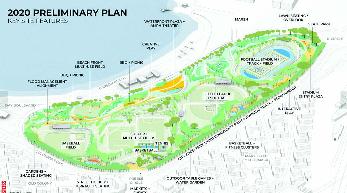
A map shown during a virtual meeting last week on plans for Moakley Park show preliminary plans for relocating some park amenities and creating new ones, including a skate park and waterfront plaza ampitheatre. Image courtesy Boston Parks and Recreation
There will be parking within the park at key spaces to make the sports fields accessible. The existing lots near the football stadium and baseball fields will remain. New lots would be positioned at the community building adjacent to a cluster of soccer fields and off Day Boulevard.
A key aspect of the plan is new lighting throughout the park. “That will really extend the hours of the park, allow more people to be there later at night, and really create some wonderful safety factors as well,” said Reed.
“It will be illuminated at night and the brightest areas will exist at the center of the park and along the pathways. The idea here is to make a park that’s more accessible to more people for more times of day. Attracting more people helps with safety, but we also want to provide lighting as a safety measure.”
A key element of the design is a new berm that would protect the park from coastal flooding and stormwater inundation, which “happens almost every time we have a storm,” Reed noted.
Julie Eaton, the lead resiliency engineer at Weston & Sampson, explained that engineers “did a series of deep probes to get a snapshot of what was below and what we found was really quite variable. We saw mostly shallow groundwater on the site and ranging degrees of fill. “Deeper down,” she said, “was more harbor drench material and fill.”
She noted that probing as deep as 224 feet identified organics and sand underneath the fill, as well as major sewer and water infrastructure, and eventually ran into “Boston Blue Clay,” a glacial marine element unique to the city, and bedrock.
“We wanted to understand what the conditions are at the site and what they mean for design,” Eaton said. “That helped us look at the vision plan from 2018 in terms of re-evaluating flood design. We will work with Boston Water & Sewer to make sure their infrastructure is protected.
“The information is helpful in assessing the heights needed for flood protection, and some of the lower heights that can provide flood risk reduction for different elements of the site.”
Reed said that the team has moved the park’s barrier back slightly on the Carson Beach side, in part “to respond to those underneath facilities. It gave us a little more space between that flood protection berm and Day Boulevard so that we have a little more waterside park than we had before.”
He added: “We’re really right at the beginning of schematic design which will last for the next eight to ten months. As we move forward, we’ll be talking about governance and partnership development. And along the way, we’ll be wanting to hear from you at a number of different points in the process.”
Intermittently throughout the design presentation, the project team employed virtual polls to gather feedback from attendees. According to the first poll, about 35 percent of attendees had been involved in previous city-led engagement sessions, and the rest were new to the process. The majority of attendees called in from South Boston and Dorchester with scatterings of others from city neighborhoods.
Respondents identified their favorite activities in the park, which included walking and sports and access to playgrounds and kids’ activities. Top concerns were poor lighting and safety, and flooded fields after rain.
“One of the first things we have to do with those existing athletic facilities is really upgrade the quality of them so that they are not flooded out and can be used more regularly,” said Reed.
A third common concern was connectivity and circulation through the park. Attendees indicated that it would be important for them to improve the current crossways to the park and walking paths through it.
Poll respondents also wanted to see seasonal events for year-round activity; cultural and musical events for more community interaction; cafes, food trucks and picnic activities; improved sports facilities; better lighting and spectator facilities; and exercise and jogging trails.
Many attendees wanted the main football field and running track to stay where they are now, close to the MBTA’s JFK/UMass Red Line station. Generally, attendees supported inclusion of more activities for seniors, better baseball fields and benches, and more activity areas scattered in the park, and the addition of a skate park.
Different aspects of the Moakley Park plan will be discussed in further detail during subsequent virtual open house sessions. Remaining sessions include:
• Sports and the stadium: Tues., Nov. 10, 6 p.m. to 7 p.m.
• Community and Play: Tues., Nov.17, 6 p.m. to 7 p.m.
• Public Health and Environment: Tues., Nov. 24, 6 p.m. to 7 p.m.
Access to all virtual events and materials will be available through the project website at www.boston.gov/parks/moakley-park
Register at: www.boston.gov/calendar/moakley-talks-planning-discussions
