June 16, 2021
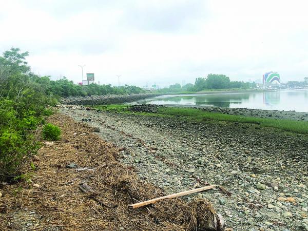
A Greenway Link Option? – There are those who want the state to consider the Dorchester Bay side of the Southeast Expressway, captured in the photo above, as a way to patch an 0.7-mile gap in the Neponset Greenway between Tenean Beach and Morrissey Boulevard. Current plans call for a tight inland route behind Freeport Street. Bill Forry photo
Last week’s Reporter carried good news about a long-awaited project to patch a 0.7-mile missing link in the Neponset Greenway, between Tenean Beach and Morrissey Boulevard, a stretch that includes a hazardous crossing at the Southeast Expressway off ramp near the Beades Bridge.
After a long pause, officials from the state’s Department of Transportation (MassDOT) led a virtual meeting on May 26 to outline their latest “preferred” route for the Greenway connection. The $8.5 million project, officials said, is now expected to start in the fall of 2022— with completion envisioned by 2024.
The current plan routes the trail along the inland side of the expressway, shooting behind several properties, including Boston Bowl, the Ramada hotel, and two state-owned salt sheds along Freeport Street. It would then cut back under the highway at Victory Road and connect trail-users to a passage through the National Grid gas tank site. That “gas tank” section of the trail — which includes an elevated, 670-foot-long boardwalk with bump-out scenic overview locations to take in the view of Dorchester Bay— is the aesthetic highlight.
Longtime advocates are thrilled that the Commonwealth is moving ahead with plans and funding for the missing link. But we also join with those who are asking planners to re-consider using the Dorchester Bay side of the expressway, instead of settling for the tight inland route behind Freeport Street. The shoreline route would require a 1,500-foot-long elevated boardwalk to connect Tenean to Victory Road Park, a state-owned land mass that juts out into the bay and could be another way to route Greenway users along a far more scenic and safer route.
One DCR official told the Reporter this week that the shoreline boardwalk was ruled out mainly due to cost — estimated to be $6 million. There’s also concern that getting through the necessary environmental permitting would be tricky.
But, without a full accounting for how much the “preferred” inland route will cost— inclusive of the land acquisition— it’s hard to measure the two alternatives. A 99-year lease agreement with National Grid that is needed to cut through their property, for example, is “not yet finalized,” according to a MassDOT spokesperson. It’s also important to note that the National Grid lease— and other right-of-way acquisition costs— are not factored into the current $8.5 million estimate for the project.
We don’t have a full picture yet of the public comments on the current project. (We’ve asked for those documents and expect to see and publish them soon.) But John and Maria Lyons— a Port Norfolk couple who have been leading advocates for the Greenway and other public assets— have asked the state agencies to reconsider the shoreline route before locking in the final design.
Engineering challenges, cost, and long-term maintenance are legitimate issues. But the public should have a chance to weigh out the pros and cons of both routes. Everyone wants to see this missing link advance without delay.
But let’s also insist that Dorchester be presented with a full set of options that can help us make an informed decision. MassDOT is still taking public comment on the Greenway project here.
Bill Forry is the executive editor and publisher of the Reporter.