March 23, 2023

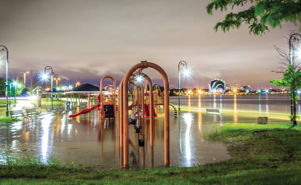
A ‘King Tide’ inundated the play area and walking paths at Tenean Beach in Port Norfolk in May 2017. Photo courtesy Boston Harbor Now
City officials are seeking local input on mitigation measures for rising sea levels that are expected to hit Dorchester’s nearly 10-mile coastal waterfront in the coming years.
The Boston Planning and Development Agency (BPDA) has scheduled a March 30 online meeting to focus on Tenean Beach and nearby Conley Street, under I-93, an area that is considered particularly vulnerable to climate change.
The agency, which has hired SCAPE Landscape Architecture to work on potential solutions to dealing with future floods, is billing the meeting as a “virtual workshop” where residents can talk through what they would like to see happen.
The effort, called “Dorchester Resilient Waterfront Project at Tenean Beach/Conley Street,” is funded through a $300,000 state grant and a $100,000 matching grant from the city of Boston. The project faces a June 30 deadline to come up with proposed solutions.
Staffers from the Massachusetts Department of Transportation and the Department of Conservation and Recreation (DCR), which is responsible for Tenean Beach, are also involved, as is the MBTA, as the Red Line and the commuter rail tracks run past the beach and Conley Street.
Visitors to the beach have close-up views of the “Rainbow Swash” gas tank owned by National Grid and the downtown Boston skyline.
City officials involved in the effort say solutions arising from this effort eventually could be deployed at a larger scale, helping to defend Boston Harbor overall from the effects of climate change. SCAPE, in touting its participation in the project, said that it will serve as a “design model for flood protection measures elsewhere along the state’s vulnerable shorelines.”
The virtual meeting will review the area’s flood vulnerability and how residents are using Tenean Beach and include a discussion on how to protect the area in the short term — over the next few decades — and the long term, defined as the year 2070.
A number of options are on the table, including flood walls, elevated earthen mounds such as “berms,” raising Conley Street, or deploying natural systems like salt marshes, according to Chris Busch, the BPDA’s assistant deputy director for climate change and environmental planning.
Those were discussed in another related planning effort, known as “Climate Ready Dorchester,” which Busch participated in. Other options included in that document, the latest version of which was released in 2020, run the gamut from a moveable flood barrier, tide gates, or floodproofing individual buildings through elevation of the first floors or relocating utilities from the basement. SCAPE was also involved with that document.
The BPDA also wants people in the neighborhood to let them know what solutions and recommendations would work for them, so that they will “have a sense of buy-in,” he added.
McConnell Park, located between flood-prone Morrissey Boulevard and I-93 to the west, recently saw improvements, including berms to protect residents and its softball and soccer fields. The parking lot was also raised, and a barrier wall, made of granite, has been placed in the park.
City Hall’s latest planning effort, zeroing in on Tenean Beach, comes as state and city officials continue to eye an overhaul of Morrissey Boulevard as its corridor experiences increased residential and commercial development. A separate state commission has been tasked with reviewing the boulevard and contiguous spaces, and the BPDA and MassDOT are conducting a study of the area.
Busch spoke to the Reporter about the Tenean Beach project as a panel of United Nations scientists warned that the worst-case scenario for climate change can be avoided, though it’s a “narrow pathway.” Countries would have to cut greenhouse-gas emissions 60 percent by 2035 in order to see any promise for the better, the Wall Street Journal reported.
Busch said city officials are using worst-case scenarios for carbon emissions in their planning efforts. “We are building them in,” he said, with the aim of keeping mitigation measures flexible enough to deal with even greater levels of rising seas.
Boston is seeking to take a proactive approach, he added. “We’re trying to limit damage to people’s homes and infrastructure.”
More information on the project is available at the following website.


