

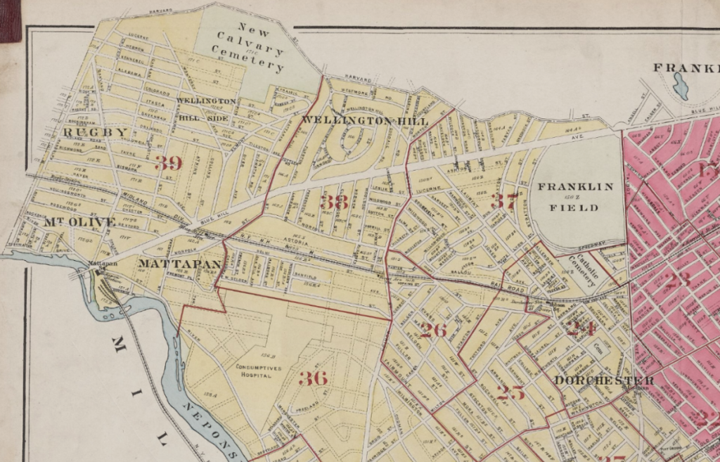
A circa 1920 map shows the Dorchester/Hyde Park line following present day Greenfield Road to Oakland Street, which is now Cummings Highway.
Among Boston neighborhoods, Dorchester has a singularly strong identity that stretches back to its founding as a Puritan settlement in 1630, a hotbed of patriot activity during the Revolutionary War, and a farming and industrial community during the 1800s. The 1870 annexation by Boston did little to dilute the neighborhood’s identity, but it did blur the lines between Dorchester and its neighbors to the north, south, and west.
Take the intersection of Blue Hill Avenue and Washington Street, which over the decades has generated more geographical confusion than perhaps any other point in Boston. While some area residents refer to Grove Hall as Roxbury, others point to the 02121 zip code as evidence that the commercial district is in Dorchester.
Then there’s the circa-1970s Boston Redevelopment Authority planning area maps that designated the area between Blue Hill Avenue, the Fairmount commuter rail line, and River Street as Mattapan.
So, where exactly is Grove Hall?
Dorchester Historical Society President Earl Taylor points to the 1630 boundary between the original Puritan settlements of Roxbury and Dorchester as a good starting point.
“With Dorchester and Roxbury, there’s at least a political line,” he says.
That line crossed present day Washington Street east of the Grove Hall commercial district where Normandy Street now intersects, followed east of current day Blue Hill Avenue until it met what in the 1630s was referred to as the Roxbury Brook, which ran east of Blue Hill Avenue, crossing Dudley Street just east of the Shirley Eustis house. It held for the 240 years from the founding of Dorchester until its 1870 annexation into the City of Boston. Then the confusion began in earnest.
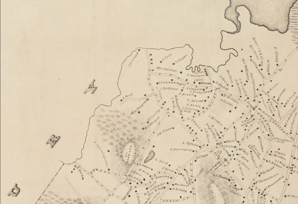
An 1850 map shows the Dorchester border following the meandering lines of the Roxbury brook, 20 years before Dorchester was annexed to Boston.
The annexation came as Roxbury and Dorchester — formerly agrarian communities — were being developed as streetcar suburbs, with large tracts of Victorian homes built to accommodate a growing middle class and horse-drawn trolley lines springing up to ferry residents to jobs in downtown Boston. The Roxbury Brook was soon filled in as new streets that bisected the former waterway were laid out. Brookford Street crosses the former stream bed, and Brook Avenue follows the eastern bank.
In the 146 years since annexation, changes in ward and precinct designations and the changing racial and religious compositions of Roxbury and Dorchester further blurred the lines.
In 1967, the US Postal Service delivered a death blow to geographical accuracy, re-designating Grove Hall as a Dorchester zip code, prompting generations of Bostonians to view a large swath of Roxbury as part of Dorchester.
The Prince Hall Masonic Lodge, which lists a 445 Roxbury Highlands exchange in its landline phone number, also lists its 24 Washington St. address as Dorchester. Elsewhere along the line, zip codes have wreaked similar havoc. The Dudley Street Neighborhood Initiative’s 550 Dudley Street address is easily 100 yards east of the Roxbury Brook dividing line yet it lists its address using the Roxbury 02119 zip code.
Colonial beginnings
In 1630, the Puritan settlement of Dorchester included what is now South Boston in the north and stretched to Plymouth Colony in the South. But shortly thereafter, towns including Stoughton and Canton split off from Dorchester. In 1660, when Dorchester residents south of the Neponset River incorporated as the town of Milton, Dorchester gained a southern border that it maintains to this day.
To the north, Boston annexed Dorchester Heights in 1804, then the Andrew Square area in 1854.
In 1847, retired Boston businessman Henry Grew moved to the section of Dorchester bordering Dedham, purchased several hundred acres of land there, then helped form the Hyde Park land company. By 1868, Grew and a group of 19th century industrialists had purchased land from Dorchester, Dedham, and Milton and incorporated the town of Hyde Park.
The boundary between Hyde Park and Dorchester — which held from 1868 until Hyde Park was annexed by Boston in 1912 — runs just to the west of Greenfield Road to Cummings Highway to the Harvard Street boundary with what was formerly Roxbury and is now Roslindale. Current Boston Planning and Development Agency maps still hew to that line.

Internal debates
Dorchester’s boundaries with Milton are set in the course of the Neponset and its boundaries with Roxbury and South Boston have been blurred. But there’s even greater confusion on its internal boundaries. Where exactly is “north” Dorchester? Where does Mattapan begin?
Mattapan has always existed as a neighborhood of Dorchester and, therefore, has never had a political boundary. The idea of what parts of Dorchester constitute Mattapan has shifted with time.
“It’s always been a moving target,” says former District 4 City Councilor Charles Yancey. “I’ve always considered Morton Street to be the boundary of Mattapan.”
While commonly accepted, Yancey’s boundary is contradicted by the Boston Redevelopment Authority’s 1971 Planning Districts map, which pushed Mattapan up to the corner of American Legion Highway and Blue Hill Avenue in the north and to the Fairmount Line and Milton Avenue in the east.
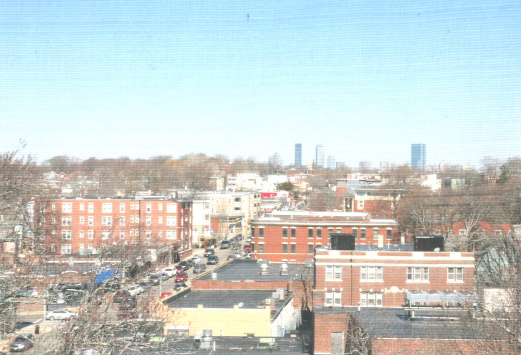
A view of Dorchester looking north from Codman Square’s Second Church of Dorchester tower. Seth Daniel photo
That controversial map appears to be the earliest reference to the singularly unpopular notion of a “north” and “south” Dorchester. Planning districts, for the sake of federal funding guidelines, had to be roughly equal in population size. Dorchester, as the city’s most populous neighborhood, was simply too large to fit into just one district.
The BRA planners drew a line that followed Freeport Street, then jogged over to Quincy Street to bisect the neighborhood. Over the ensuing 55 years, the meaning of north and south Dorchester has morphed to reflect the shifting racial divides.
“Some areas of south Dorchester are north of parts of north Dorchester,” said longtime Dorchester resident and community organizer Lew Finfer. “It’s taken on racial connotations.”
As The Reporter’s Bill Forry pointed out in a pointed 2017 editorial titled “It’s Dorchester-PERIOD.”
“Past city administrations that used it more heavily assigned Savin Hill to ‘south’ and Codman Square to ‘north.’ Absurd.”
District 3 City Councillor John FitzGerald says that in the quest to define sub-neighborhoods such as Mattapan and Uphams Corner, important interstitial places often get ignored. He points to the commercial district on Morton Street that runs from the intersection of Gallivan Boulevard to the Fairmount Line tracks. Is it Mattapan? Is it Dorchester? Fitzgerald refuses to say.
“You’re kind of in Mattapan and you’re kind of in Dorchester,” he commented. “Sometimes areas get overlooked because you’re not in one place or another.”
Taylor of the Dorchester Historical Society takes the long view. The lines between Mattapan and the rest of Dorchester have moved so many times over the decades, they’ve almost become irrelevant.
“In my mind, it’s all Dorchester,” he says. “Mattapan has always been Dorchester.”
