June 29, 2017

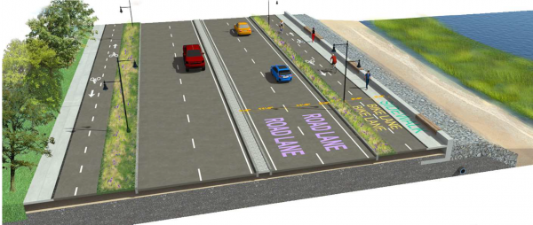
DCR sketch shows rendering of sea side Morrissey Blvd.
With bike lanes, roadway widths, and signaling a bit more defined this time around, the Morrissey Boulevard redesign is at about 25 percent, Department of Conservation and Recreation officials told community members at a reasonably well attended meeting on the critical artery Tuesday night.
Mark MacLean, a DCR project engineer, said the roadway deals with about 50,000 cars a day. The multi-lane route stretches from just below the notorious Kosciuszko Circle, which is not included in the plan, down to Neponset Circle in three segments.
“What we’re trying to do throughout the project is maintain capacity where it’s needed, at the intersections... which are typically the most constrained and challenging locations,” said Gary McNaughton, a traffic engineer with McMahon Associates. “And then in the areas where we can repurpose some of that pavement over to provide better accommodations for bikes and [pedestrians] and better landscaping features, we’re making sure we’re able to do that.”
The last public meeting was held last September, when initial design concepts were presented. According to the timeline laid out at Tuesday’s meeting, DCR expects to have a session at 75 percent design in October. Eyeing January 2018 for completed design, the department anticipates a pre-construction final meeting in the fall of 2018.
Since the September meeting, designers have updated bicycle and pedestrian connections, including two-way cycle tracks between Mt. Vernon Street and Bianculli Boulevard at the entrance to UMass Boston. The beach access area for boat launches near the Savin Hill Yacht Club has been moved 300 feet north with the addition of a 18- to 24-inch high retaining wall and a slope of riprap, or protective stone.
A traffic signal at Victory Road would allow U-turns in both directions and left turns in the southbound direction. Traffic changes at Neponset Circle would allow two-way circulation under I-93. In another distinct difference, Beades Bridge would be reduced to two lanes in each direction, with wider ADA-compliant sidewalks.
One element consumed conversation – a controversial plan to drop a full traffic lane is still included in the design. This prompted some back and forth between residents insistent that traffic will be unbearable and engineers, who say a better-organized route will minimally leave traffic unchanged and likely improve the overall flow of vehicles.
“What you are proposing is ludicrous,” an attendee said during a question and answer segment. He asserted that the existing gridlock was already such a mess that removing a lane would only make it worse, a sentiment later echoed by other residents.
However, McNaughton said in reply, they are improving the lane and signal efficiency to simplify driving patterns, leaving a “much cleaner, more organized intersection.”
Another traffic alteration just past the Red Line overpass prompted concern, as a southbound-to-northbound U-turn near a Dunkin’ Donuts would be eliminated. Drivers would have to continue along through Neponset to turn around, which some said was worrying because of limited sightlines.
Bicyclists who spoke at the meeting were pleased. Bike paths travel along the entire length of the boulevard, mostly as two-way lanes. Near the Red Line underpass, however, the lane narrows and a one-way bike route hugs the turn, buffered by a guardrail.
Many questions revolved around making specific connections to the neighborhoods.
Although the northernmost stretch of Morrissey Boulevard goes past several prominent parcels – including the Boston Globe site and the recently sold Herb Chambers property at 75 Morrissey Blvd. – the roadway does not interact with them, DCR officials said. The one exception is refining the lane configurations starting around the Globe access point across from Boston College High School. An existing service road would become one lane, leading to a signal across multiple lanes, to better phase traffic as it moves toward Bianculli Boulevard.
The stretch of road is often flooded is the DCR-designated middle segment – from Patten’s Cove Bridge to Freeport Street – making it the most vulnerable and, therefore, of highest priority. Completion of each of the three segments is contingent on funding.
A $3.2 million one-year design process is fully funded for the roadway, a decades-long hope for those living on the often-flooded or unreliable path. DCR planners said they anticipated about 24 months to construct each section, closing off a few lanes at a time. If completed in three parts on that schedule, the project would take six years.
The full presentation, including roadway elevations for each segment of the stretch and renderings of common areas, is available on the DCR website. Public comments for the 25 percent design phase will be accepted through July 18.
Topics:


