August 11, 2011
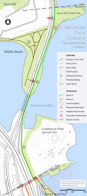
 Proposed path: A state map shows how the Neponsest Greenway would run through the gas tank site next to Dorchester Bay.
Officials from the state Department of Conservation and Recreation (DCR) will apply for federal stimulus dollars to complete the Neponset Greenway trail, a project that would include a long-sought connection through the landmark rainbow gas tank property next to Dorchester Bay and a one-mile extension through Mattapan and Milton.
If DCR receives the $10 million federal grant, the agency will contribute an additional $2.5 million to the project. The funding would add three miles to the existing five mile multi-use trail that runs mainly through Dorchester along the scenic Neponset River. Once completed, the eight mile Greenway would connect the Blue Hills to Boston Harbor.
The federal funds would pay for a key missing link along the current waterfront route in Dorchester by traversing the property next to the rainbow gas tank. The current owner of the tank, National Grid, has granted DCR an easement, allowing for a new, safer connection between Tenean Beach and Morrissey Boulevard.
This new segment of the Greenway path would start at Victory Road, running along the western periphery of the gas tank site and near National Grid’s solar array project, according to DCR. The route will also function as an emergency access point, and the company plans to set up the path so that it could be shut down for security reasons. “We need to be able to provide and maintain security to that site,” said Fouad Dagher, program manager for the solar development for National Grid.
The gas tank segment would connect to Morrissey Boulevard via a bridge or a boardwalk that would span the marsh below and join the existing sidewalk on the boulevard, allowing pedestrians and cyclists to bypass the perilous exit ramp from I-93 northbound.
The gas-tank segment of the Greenway then would be the latest northward link in the trail that would lead from the already existing path at Pope John Paul II park, along the edge of the former Shaffer Paper site in Port Norfolk, then along Water Street and Tenean Beach to Victory Road.
On the other end of the existing Greenway trail, which currently ends at Central Avenue in Milton, state officials have reportedly reached an accord over where to build a one-mile extension that will connect to Mattapan Square.
DCR officials plan to unveil the proposed alignment of the extension at a public meeting at the Foley Senior Residences in Mattapan on Aug. 30. MBTA officials, who had raised safety concerns about the possibility of an at-grade crossing as part of the trail that could run through the Mattapan Square MBTA station, are also expected to attend.
At a meeting of the Neponset River Greenway Council last Wednesday, the DCR’s project manager Cathy Garnett remained tight-lipped when questioned by council members about the extension’s precise configuration. The Reporter wrote earlier this year that the state’s preferred route for the connection would includ parts of both Milton and Boston, with part of the trail on the Milton side at Central Ave. crossing the river near the Ryan playground and heading down the Mattapan side to the Mattapan Square T station.
The trail has drawn controversy from potential abutters, some of whom argued that several of the alternative plans could involve the blasting of rocks near their homes and the destruction of trees.
“Things have changed with the design of the trail,” Garnett told the dozen or so council members who turned out Wednesday night.
Garnett also acknowledged that a deal had been reached between the DCR and the MBTA. The transit agency has resisted plans to create a new grade crossing for the Greenway near the Mattapan Square station— an obstacle that threatened to derail the Mattapan segment of the trail entirely. Now, both sides say they have reached a compromise that will allow the Greenway to traverse the T property near the station, crossing the trolley tracks via a flyover that will need to be designed and constructed.
Richard Davey, the MBTA’s general manager, told the Reporter last week that “at this point” the agencies are looking at a “modest” pedestrian bridge over the trolley tracks. But, he added, “there’s a lot more community process to be had.”
An MBTA official told the Reporter that the pedestrian bridge is a necessary element of the emerging plan, because one requirement of the federal fund package is that no new at-grade crossings can be added to the project due to safety guidelines. Cost estimates for the bridge were unavailable.
The Aug. 30 community meeting will allow for public input on the final deal as DCR sprints to apply for a federal grant by October, Garnett said at last week’s meeting with the Neponset Greenway Council.
Boston Natural Areas Network president Valerie Burns called the potential compromise “an exciting opportunity to really unite the different constituencies along the trail.”
“I think we’re all eager to see the resolution the MBTA and DCR have come up with,” she said.


