
At a virtual BPDA meeting last Wednesday night, community members reacted largely positively to details and images presented by the development team focusing on urban design elements of the Dorchester Bay City project (DBC) proposed for Columbia Point.
The meeting — the second in a series— was broadcast on Zoom and translated into various languages including Spanish, Vietnamese, Haitian Creole, and Cape Verdean Creole, an accommodation that Accordia Partners co-owner Kirk Sykes said reflected the spirit of inclusiveness driving the project.
“We’re trying to make Dorchester Bay City the most inclusive, empowering, and accessible place in Boston,” said Sykes. “This is a very special place. We are also mindful that we have a chance to transform what has been for many, many years now asphalt and cars into a vision that includes 20 acres of additional open space that will enhance public access to the water’s edge.”
The design-heavy presentation, led by Sykes, Tamara Roy of Stantec, and architects involved in the project, highlighted the team’s intent to connect the site seamlessly to both the existing neighborhood and the waterfront, while incorporating pedestrian and bicycle-friendly infrastructure.
Roy emphasized their careful consideration of the Columbia Point Master Plan, a vision for the region developed by the city and the Columbia and Savin Hill neighborhoods in 2011.
Th team members “respect and value” the effort that went into the Columbia Point Master Plan, said Roy, adding, “we have taken many portions of that plan into our street and walk layout.”
As it stands, the project would bring to the neighborhood 1,740 housing units (20 percent of which would be affordable), 4 million square feet of lab and office space, 150,000 square feet of room for shopping or dining, and 20 acres of open space.
Roy pointed out that much of the former Bayside property represents untapped potential. The DBC project would transform those parking lots into a transit-focused community that Sykes said will welcome folks “by land, by sea, by road, and by T,” complete with improved sidewalks connecting Mt. Vernon Street to the JFK/UMass T station, a potential ferry service providing connection to downtown, and separated bike lanes on “every single street” within the project.
“The area is currently very auto-centric, and the goal of our urban design is to weave together the two sites and integrate the project into the existing neighborhood,” said Greg Minott of the local architecture firm Dream Collaborative. “Our other goal is to create a more pedestrian and bicycle-friendly place.”
Demetrios Staurinos, from Philadelphia-based OLIN Architecture, described how four pathways or “fingers” with distinct characters would connect Mt. Vernon Street to the waterfront.
“These would be more than just streets but actual linear parks,” he said, that would create green space, gathering points, and room for outdoor dining patios, in addition to routes for motorists, cyclists, and pedestrians alike.
One of those fingers, a central “Boardwalk” passageway, would be bookended by an “Innovation Plaza” on the Morrissey parcel that now houses Santander Bank and a “Porch,” a garden-like gathering space abutting the DCR Harborwalk.
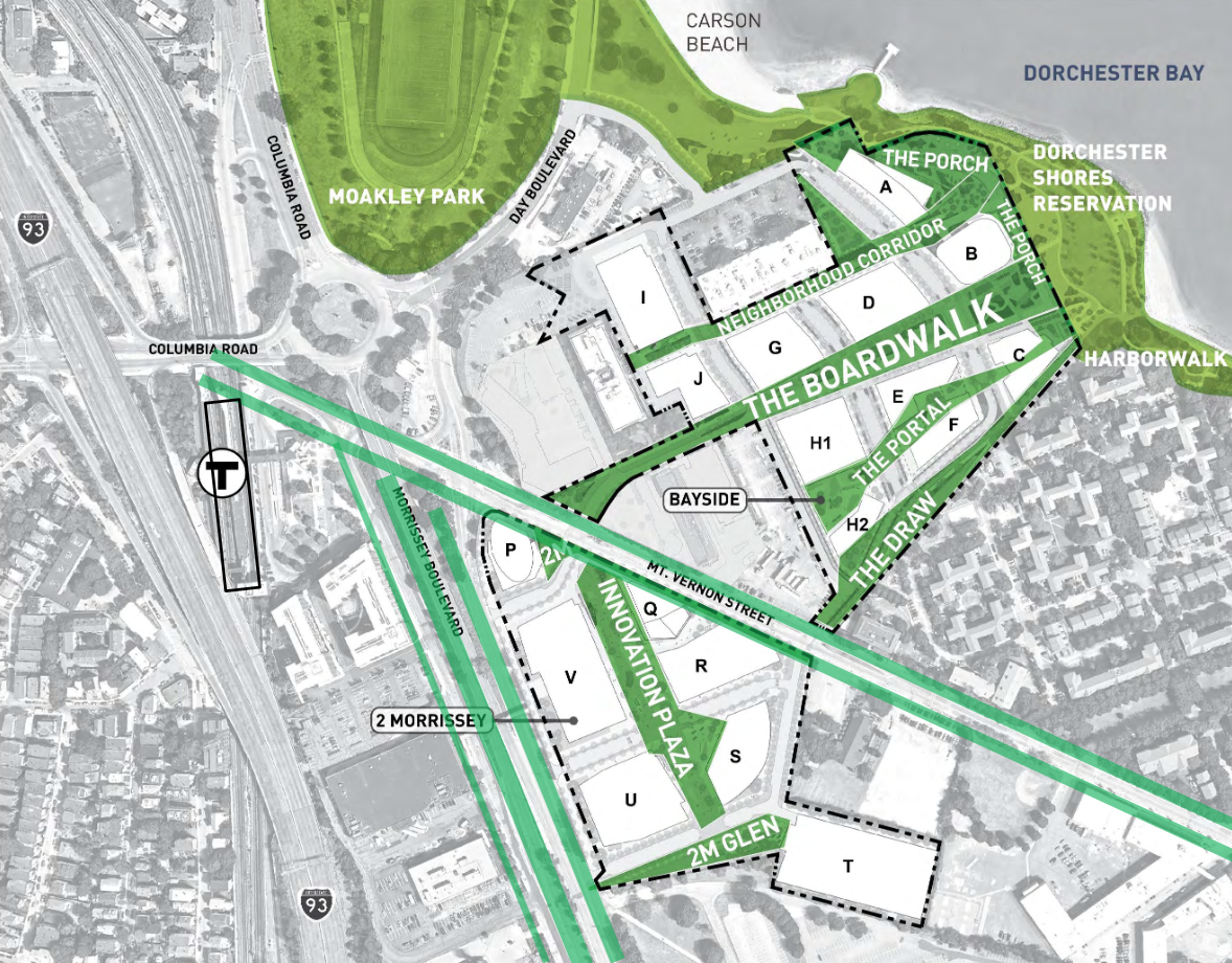
A map displayed during the meeting shows how the site might be laid out with four pathways or”fingers” bisecting the property.
In a Q&A section following the meeting, RODE Architects principal Kevin Deabler applauded the development team’s idea to hold a design competition for certain buildings in the complex, an initiative he hopes will “raise the bar” for the project.
“I encourage this notion of a competition,” he said, “and I look forward to seeing some of the world’s greatest architects look at this as a challenge for them.”
A good portion of the community questions and comments took up transportation issues, with residents curious how the project will dovetail with several infrastructure projects slated for Morrissey Boulevard, Kosciusko Circle, and Moakley Park.
“Things like shopping and retail spaces are huge traffic generators,” said Michael Corcoran, the chief operating officer at Corcoran Jennison, an abutter of the DBC site. “There needs to be enormous infrastructure improvements for people to get in and out of this site, not only for people living and working here but also for visitors.”
Dorchester resident Adam Pieniazek suggested the project’s current allotment for 1,289 underground parking spaces was excessive. He pointed to a Twitter poll he conducted asking people if they would live in a car-free Dorchester Bay City. He said 50.5 percent responded ‘yes,’ and another 13.2 percent said, ‘maybe.’
“So, I think there’s a lot of promise for such a thing, and it solves a lot of the problems that people raise about traffic and K circle,” said Pieniazek.
Sykes was receptive to multiple suggestions that the project design include public art installations or murals created by local artists, noting that such an initiative “may take many forms, but I imagine that will be a robust piece, and we’ll very much embrace local artists in giving them a place to do what they do and to make some money doing what they do on our sites.”
Erica Shwarz, a member of the community group Dorchester Not For Sale, expressed concerns about Dorchester residents being priced out of the project’s housing structures.
“It seems like it’s inclusive for everyone to walk through, but not live in,” said Shwarz. “Market price housing will not be affordable to a huge percentage of Dorchester families whose living costs are going to go up because of this development. …Unless there is a much longer process, this development, like so many others that are being pushed through really quickly like the one in East Boston, is going to devastate our city.”
BPDA project manager Aisling Kerr noted that the project’s public comment period has been extended to Dec. 11, and that upcoming community meetings will address issues of transportation and housing.
Those meetings are scheduled as follows:
Nov. 4: Open Space, Public Realm & Resilience; Nov. 16: Transportation & Infrastructure; Dec. 2: Topic to be determined.
More information about the development proposal and the Article 80 process can be found on the project page at bostonplans.org.
